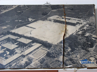
The Evolution of a Genki School
This morning we had a decent tremor, lasting about 30 seconds or more. And this time it was during daylight hours, so I could look out the window to see if anything was moving. The concrete telephone poles held firm, but the dead tree was a-swayin. Well, the two branches were. This was the kind of tremor that builds up power as it goes. Just when I thought it might stop, it got a little stronger. I'm using the terms "power" and "stronger" loosely here, as it was very mild as far as earthquakes go. But fun nonetheless.
Aaanyhoo... Friday was my last day at GS (AKA Ghetto School, AKA Genki School), and my last proper school day in my town. I took the opportunity to take some pictures of the aerial shots of the school (on display in the hallway) to illustrate how this area, and that school in particular have changed over the years.
 The present building.
I don't know when the school was built, but I'm going to put this picture in the late 80's, early 90's.


2 Comments:
Wow, always amazing to run across old photos like these, esp when living in a foreign country...
Japan, to mew is a place I call home however I have no memory of my surroundings, other than the memories I have created in the last 8 years...
1:19 PM
Where is this, Ena shi?
Just going by the katakana in the first photo, I live in Gifu City. Have you ever taken the old akechi line train to akechi? It is a nice trip through the mountains from ena city.
4:52 PM
Post a Comment
<< Home